Generate a labeled diagram of the Earth’s layers, crust, mantle, outer core, and inner core, with depths and states, or a blank layers of the Earth diagram with numbered lines for students to fill in, plus its answer key. Add the lithosphere and asthenosphere, continental and oceanic crust, or the Moho and core boundaries, then download a clean figure for worksheets and slides.
Labeled, numbered or blankDepths to 6,371 kmMatching answer key
Depths checked against USGS and NASA
Worksheet + answer key pairs
Print-ready PNG
AI Layers of the Earth Diagram Generator
Describe the view and the layers to label, or pick a blank worksheet from the Labels menu.
489 / 2000 characters
Generate a publication-ready PNG from your description.
Preview
Earth Layers Diagram Example Previews
Target aspect ratio: 4:3
Sample previews. Describe your diagram to generate your own earth layers figure.
Labeled and Blank Earth Layers Diagram Examples
A labeled globe cutaway, a blank layers of the Earth worksheet, a numbered answer key with depths and states, a simple four-layer diagram, and a detailed version with the lithosphere, the asthenosphere, and depth ranges.
Prompt
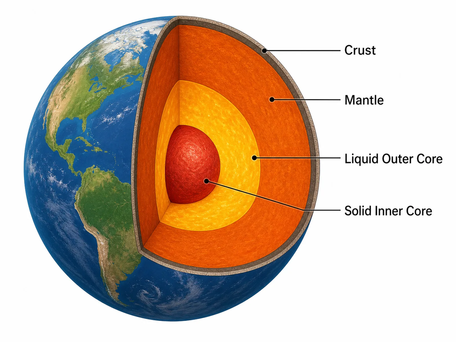
Create a labeled layers of the Earth diagram on a white background: a realistic globe with blue oceans and green continents and a wedge cut out of the front to show the inside. From the outside in, draw a thin grey-brown crust, a thick orange mantle as the widest layer, a yellow outer core and a deep red inner core ball at the centre. Label "Crust", "Mantle", "Liquid Outer Core" and "Solid Inner Core" on the right with thin leader lines and readable sans-serif text.
Use this example
Prompt
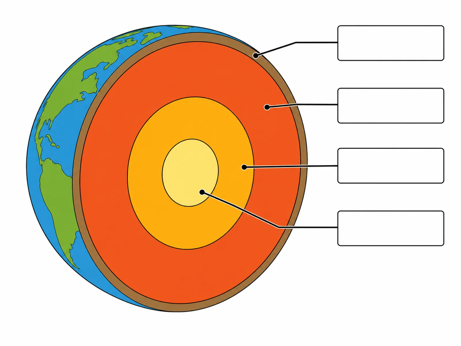
Create a blank earth layers diagram worksheet for students to label. Draw a globe with blue oceans and green continents, cut open so the flat cut face shows the layers as concentric bands: a thin brown crust, a wide orange-red mantle, an orange outer core and a pale yellow inner core. Draw four leader lines, one ending in each layer from the crust inward, each running to an empty rounded box on the right, and put no layer names, depths, key or word bank anywhere on the image.
Blank worksheetElementary
Use this example
Prompt
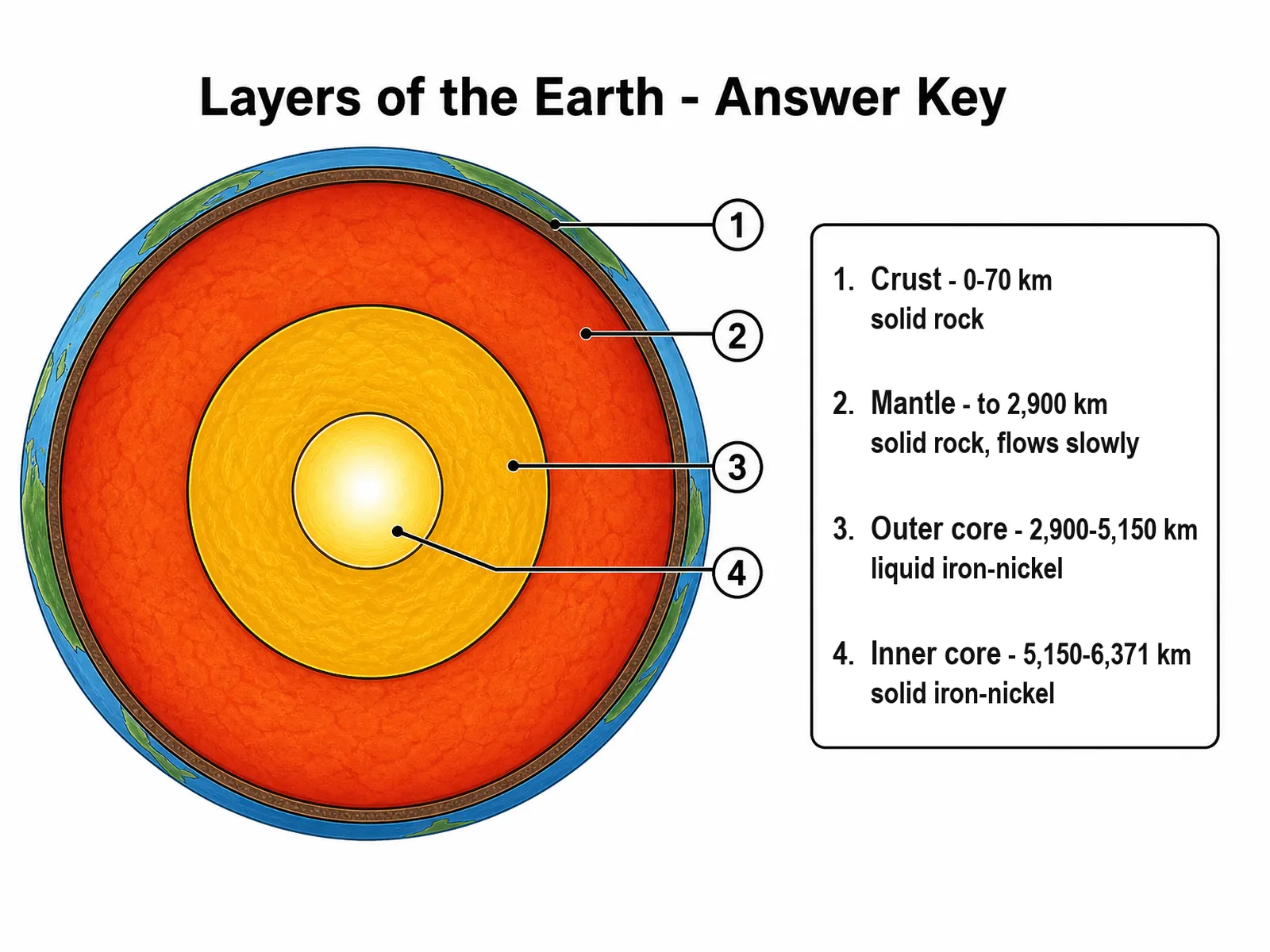
Create a numbered layers of the Earth answer key on a white background, titled "Layers of the Earth - Answer Key". Draw the Earth as a flat cross-section of concentric circles: a thin brown crust under a blue and green surface, a wide red-orange mantle, a yellow-orange outer core and a glowing pale yellow inner core. Number the layers 1 to 4 from the surface inward with circled numbers at the ends of the leader lines, and add a key box on the right reading "1. Crust - 0-70 km, solid rock", "2. Mantle - to 2,900 km, solid rock, flows slowly", "3. Outer core - 2,900-5,150 km, liquid iron-nickel" and "4. Inner core - 5,150-6,371 km, solid iron-nickel".
Numbered with keyCross-section
Use this example
Prompt
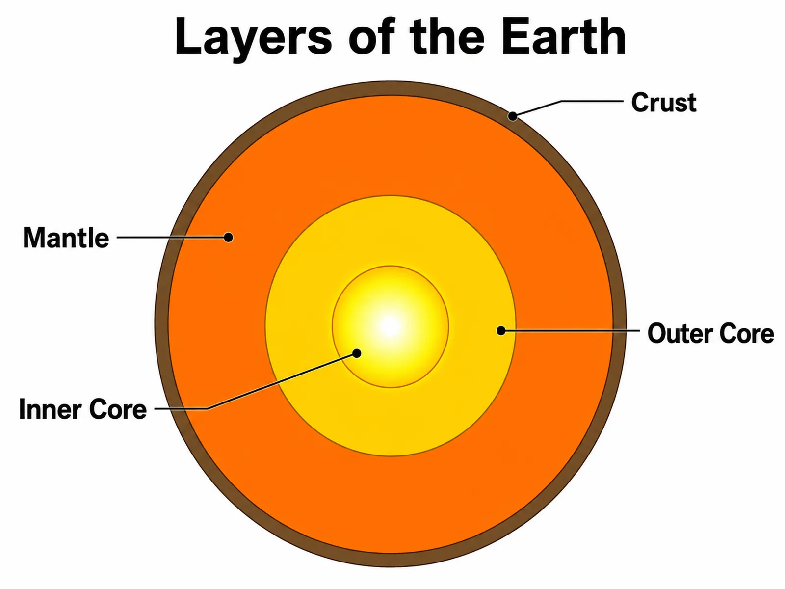
Create a simple layers of the Earth diagram for younger students, titled "Layers of the Earth". Draw a flat cross-section of concentric circles on a white background: a thin brown crust, a wide orange mantle, a yellow outer core and a glowing white-yellow inner core. Label "Crust", "Mantle", "Outer Core" and "Inner Core" in large bold text with thin leader lines that end inside each layer.
Cross-sectionElementary
Use this example
Prompt
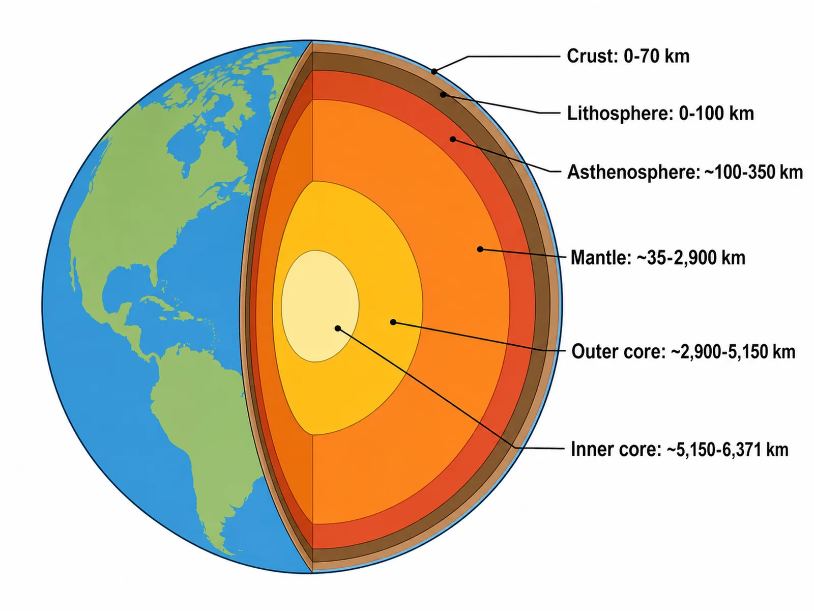
Create a detailed layers of the Earth diagram on a white background: a globe with blue oceans and green continents, cut in half so the flat cut face shows the layers as concentric bands. Below the thin crust draw a darker rigid band of uppermost mantle, then a red asthenosphere band, the orange mantle, a yellow outer core and a pale yellow inner core. Label each with its depth range on the right: "Crust: 0-70 km", "Lithosphere: 0-100 km", "Asthenosphere: ~100-350 km", "Mantle: ~35-2,900 km", "Outer core: ~2,900-5,150 km" and "Inner core: ~5,150-6,371 km".
High school
Use this example
Prompt
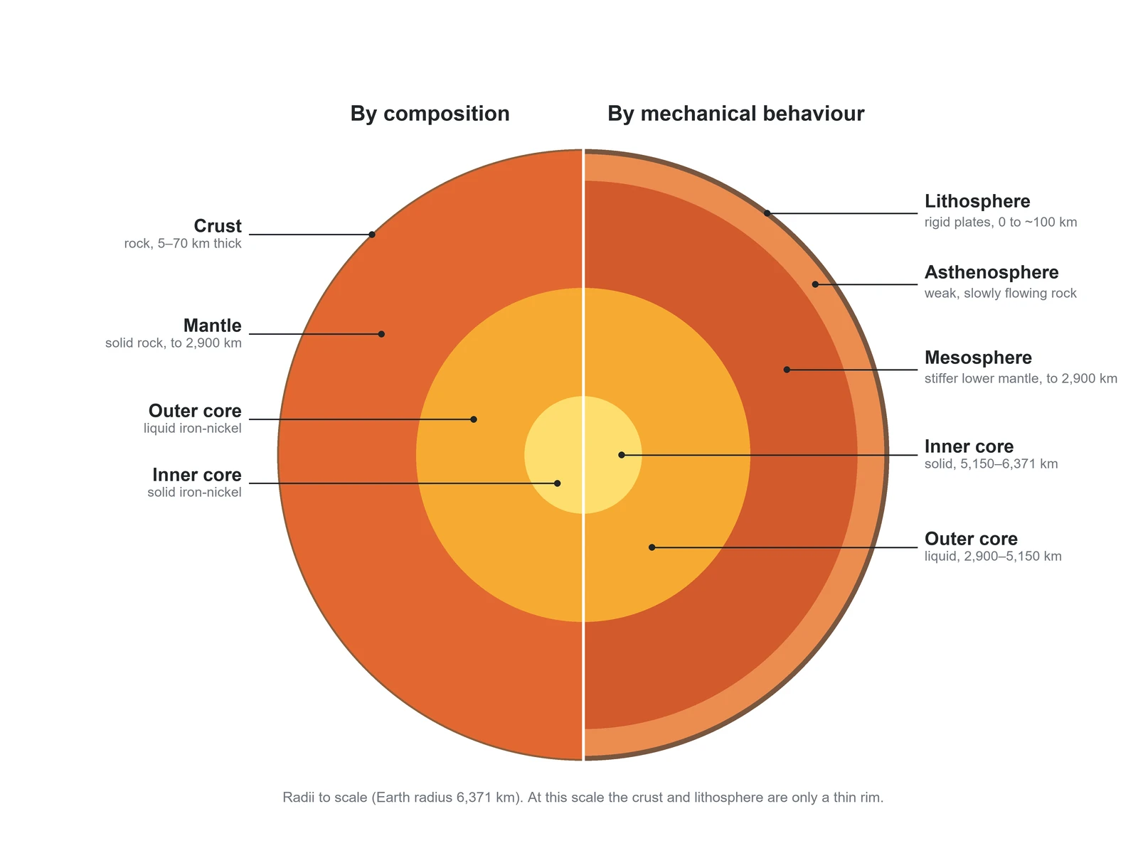
Create a layers of the Earth diagram that compares the two ways of dividing the planet, on a white background. Draw one circular cross-section with the radii to scale (Earth radius 6,371 km, outer core from 2,900 km, inner core from 5,150 km) and split it down the middle with a thin white line. Title the left half "By composition" and label the crust (rock, 5–70 km thick), mantle (solid rock, to 2,900 km), outer core (liquid iron-nickel) and inner core (solid iron-nickel). Title the right half "By mechanical behaviour" and label the lithosphere (rigid plates, 0 to about 100 km), the asthenosphere (weak, slowly flowing rock), the mesosphere (stiffer lower mantle, to 2,900 km), the liquid outer core and the solid inner core. Use horizontal leader lines ending in small dots inside each layer, and add a grey note that the crust and lithosphere are only a thin rim at this scale.
Compositional vs mechanicalHigh school
Use this example
How to make a labeled or blank layers of the Earth diagram
1
Pick the view, level, and labels
A globe cutaway, a cross-section, a true-scale slice, compositional vs mechanical layers, a crust and plates close-up, or seismic waves. Set the level, then choose labeled, numbered with a key, a blank worksheet, or a worksheet with a word bank.
2
Generate the diagram
The generator draws the four layers in order with the mantle as the thickest, the outer core liquid and the inner core solid, and uses one consistent set of depths from the crust to the centre at 6,371 km.
3
Make the answer key, check, and export
For a worksheet, make the answer key from the same result so the numbers match. Check the order, the thicknesses, the states, and any depths, then download the PNG.
Layers of the Earth key facts
Main layers
Crust, mantle, outer core, inner core
Earth’s radius
6,371 km to the centre
Oceanic crust
5 to 10 km thick
Continental crust
About 30 km, 70 km or more under mountains
Mantle
To 2,900 km; solid; 84% of Earth’s volume
Outer core
2,900 to 5,150 km; liquid iron and nickel
Inner core
5,150 km to the centre; solid; about 5,400 °C
Lithosphere
Crust + uppermost mantle, about 100 km
Asthenosphere
Weak, slowly flowing solid below the lithosphere
Crust–mantle boundary
Moho (Mohorovičić, 1909)
Inner core discovered
1936, by Inge Lehmann
Deepest borehole
About 12 km (Kola), still in the crust
What is a layers of the Earth diagram?
A layers of the Earth diagram, also called an earth layers diagram or a diagram of earth layers, is a labeled drawing of the inside of our planet. The usual version is a globe with a wedge cut out, or a flat cross-section of concentric circles, that names the crust, the mantle, the outer core, and the inner core from the outside in. It is a staple of earth science because it ties together the rocks at the surface, the movement of the plates, volcanoes and earthquakes, and the Earth’s magnetic field.
In class a diagram of the Earth’s layers is used in two ways. A labeled version, with depths and states, works as a reference or an answer key. A blank layers of the Earth diagram keeps the drawing and the leader lines but leaves the names off, so students write them in. This page makes both from one description, plus a numbered version with a key and a worksheet with a word bank.
The four main layers, from the surface to the centre
Crust: the thin, rigid outer skin of rock. It is 5 to 10 km thick under the oceans and about 30 km thick on average under the continents, and it makes up only about 1 percent of the Earth’s volume.
Mantle: solid silicate rock, richer in iron and magnesium than the crust, from the base of the crust down to about 2,900 km. It is the thickest layer and holds 84 percent of the Earth’s volume. It is hot enough to creep slowly over millions of years, and that slow flow moves the plates above it.
Outer core: a layer of liquid iron and nickel, with some lighter elements, from 2,900 to 5,150 km down, about 2,250 km thick. Its churning generates the Earth’s magnetic field.
Inner core: a solid ball of iron and nickel with a radius of about 1,220 km, from 5,150 km down to the centre at 6,371 km. NASA puts its temperature at up to about 5,400 °C, but the pressure keeps it solid.
Depths and thicknesses, with one consistent set of numbers
Published figures differ by a few tens of kilometers because the boundaries are measured with seismic waves and rounded differently. Mixing sources is how worksheets end up with depths that do not add up, so this page and the generator use one set throughout.
Earth’s radius: 6,371 km on average (the diameter is about 12,742 km; 12,756 km at the equator).
Base of the crust (the Moho): 5 to 10 km under the oceans, about 30 km under the continents, and 70 km or more under high mountain ranges.
Base of the mantle (the core-mantle boundary): about 2,900 km.
Top of the inner core: about 5,150 km.
Centre of the Earth: 6,371 km.
Mechanical layers: lithosphere to about 100 km; asthenosphere below it, its base placed anywhere from about 200 to 660 km depending on the book; mesosphere (lower mantle) from 660 to 2,900 km.
Drawing the layers to scale
Almost every earth layers diagram exaggerates the crust, and it has to. On a cross-section 20 cm across, with a radius of 10 cm, the continental crust would be about half a millimeter thick and the oceanic crust about a tenth of a millimeter: thinner than a pencil line. The USGS describes the crust as literally only skin deep.
The other layers are easier. At that size the mantle is a band about 4.5 cm wide, the outer core about 3.5 cm, and the inner core a ball about 1.9 cm in radius, so the whole core fills just over half the radius. The inner core is about 70 percent of the Moon’s radius. A correct diagram can thicken the crust, but it should keep the mantle the widest band and say that the crust is exaggerated. The true-scale slice view draws everything in proportion, with a magnified callout for the crust.
Compositional layers vs mechanical layers
Geologists divide the Earth in two ways, and many worksheets ask for both. The compositional layers are defined by what the rock or metal is made of; the mechanical layers by how it behaves, rigid or weak, solid or liquid.
Compositional: crust (lighter silicate rock), mantle (denser silicate rock rich in iron and magnesium), core (iron and nickel).
Lithosphere: the rigid outer shell, made of the crust and the uppermost mantle, about 100 km thick on average. It is thinner under mid-ocean ridges and thicker under old continents.
Asthenosphere: solid but hot and weak enough to flow slowly, so the lithosphere can move over it. Its weakest part, about 100 to 200 km down, is close to the melting point of the rock, and some magma comes from there. Its base is gradual, so books place it anywhere from about 200 km to 660 km.
Mesosphere: the lower mantle, from 660 to 2,900 km. It is hotter than the asthenosphere, but the higher pressure makes it stronger. (It has nothing to do with the mesosphere layer of the atmosphere, 50 to 85 km above the ground.)
Outer core and inner core: the same two layers in both schemes, because the change from liquid to solid is both a mechanical and a compositional difference.
Continental crust vs oceanic crust
The crust comes in two very different kinds, and a good diagram draws them differently.
Thickness: continental crust is about 30 km thick on average and much thicker under mountains, with a deep "root" beneath them; oceanic crust is only 5 to 10 km.
Rock: continental crust is mostly lighter, granite-like rock rich in silica and aluminium (older books call it sial); oceanic crust is basalt and gabbro, richer in iron and magnesium (sima).
Density: oceanic crust is denser, so it sits lower, under the oceans, and it can sink into the mantle at subduction zones. Continental crust is too buoyant to sink far.
Age: parts of the continental crust are about 4 billion years old. Oceanic crust is constantly made at mid-ocean ridges and destroyed at trenches, so it is rarely older than about 200 million years.
The boundaries: Moho, Gutenberg, and Lehmann discontinuities
A discontinuity is a depth where earthquake waves suddenly change speed, because the material changes. Three are named on most diagrams of the Earth’s layers.
Mohorovičić discontinuity (Moho): the crust–mantle boundary, found in 1909 by Andrija Mohorovičić. Earthquake waves speed up sharply as they cross it into the denser mantle rock. It is 5 to 10 km down under the oceans and 30 to 70 km under the continents.
Gutenberg discontinuity: the mantle–core boundary, about 2,900 km down. The core itself was discovered by R. D. Oldham in 1906; Beno Gutenberg later pinned down its depth. Below it, S waves disappear and P waves slow sharply as they enter the liquid outer core.
Lehmann discontinuity: on school diagrams, the outer core–inner core boundary at about 5,150 km, after Inge Lehmann, who showed in 1936 that the Earth has a solid inner core. Seismologists usually call it the inner-core boundary and use the name Lehmann discontinuity for a weaker boundary in the upper mantle, about 220 km down.
Some syllabuses also name the Conrad discontinuity, a boundary inside the continental crust between its upper and lower parts. It is not found everywhere, so most diagrams leave it out.
How seismic waves reveal the layers
No one has drilled through the crust: the deepest hole, on Russia’s Kola Peninsula, reached about 12 km. Everything below is known from earthquake waves, from the Earth’s density, and from laboratory experiments at high pressure.
P waves (primary waves) are compressional and pass through solids and liquids. S waves (secondary waves) are shear waves and pass only through solids.
S waves do not pass through the outer core. That is the main evidence that it is liquid, and it leaves a large S-wave shadow zone on the far side of the Earth from an earthquake.
P waves bend sharply where they enter the core, which leaves a P-wave shadow zone where few direct P waves arrive. Faint P waves that do arrive in that zone, reflected from a solid inner core, are what led Inge Lehmann to discover it.
The Earth as a whole is about twice as dense as its surface rocks, which told scientists long ago that the interior must be made of something much denser: the iron core.
Labels to use on a blank earth layers diagram, by level
The right number of labels depends on the class. These are the sets the level menu uses when your description does not list its own.
Elementary: the four layers, crust, mantle, outer core, and inner core.
Middle school: the four layers with solid or liquid under each and the depth of each boundary.
High school: continental and oceanic crust, the four layers with depths and states, the lithosphere and asthenosphere, and the Moho, Gutenberg, and Lehmann discontinuities.
College: the compositional and mechanical layers, the transition zone between 410 and 660 km, and the main material of each layer.
Any level: a clean unlabeled cutaway for coloring, a quiz read aloud, or a slide background.
The layers of the Earth and plate tectonics
Plate tectonics is the reason the layers matter beyond the diagram. The lithosphere is broken into plates, about twelve large ones according to the USGS, each carrying continents, ocean floor, or both. They move over the weak asthenosphere at a few centimeters a year, slower than fingernails grow.
Where plates pull apart at mid-ocean ridges, mantle rock rises, partly melts, and forms new oceanic crust. Where an oceanic plate meets another plate, the denser oceanic lithosphere sinks back into the mantle at a subduction zone, making deep trenches, earthquakes, and volcanoes. Where two continents collide, neither sinks, and the crust crumples and thickens into mountain ranges such as the Himalayas. The crust and plates close-up view draws these settings on one figure.
Using a blank layers of the Earth diagram in class
Start blank, end labeled: hand out the blank earth layers worksheet, then show the answer key made from the same result so every number matches.
Add the numbers: have students write the depth of each boundary and whether each layer is solid or liquid next to its name.
Two schemes, one Earth: use the compositional vs mechanical view to show that the lithosphere includes the top of the mantle.
Fix the proportions: compare the usual diagram with the true-scale slice and discuss why textbooks exaggerate the crust.
Word bank or not: include one for a scaffolded lesson and leave it out for a test. It is alphabetical, so its order gives nothing away.
Temperature and pressure inside the Earth
Both rise steadily with depth. Near the surface, the temperature in the crust climbs by roughly 25 to 30 °C for every kilometer you go down, which is why deep mines need cooling. The rate slows deeper down, but by the centre the temperature reaches about 5,400 °C, according to NASA, about as hot as the surface of the Sun. Pressure climbs even more dramatically, to millions of times the pressure of the air at sea level. The balance between the two decides each layer’s state: the outer core is hot enough to be liquid, while in the inner core the pressure wins and the iron is solid.
Most common mistakes on a layers of the Earth diagram
These are the errors image models, and plenty of printed handouts, make most often. Check each one before a diagram goes into graded work.
MistakeCorrect
MistakeInner core and outer core swapped, or the outer core labeled solid
CorrectOuter core: liquid, 2,900–5,150 km. Inner core: solid, 5,150 km to the centre
MistakeThe mantle drawn or labeled as liquid magma
CorrectThe mantle is solid rock that flows very slowly; magma forms only where rock melts locally
MistakeThe crust as thick as the mantle
CorrectThe crust is under 1% of the radius; the mantle is the thickest layer, about 2,900 km
MistakeAn extra molten layer between the crust and the mantle
The layers of the Earth by depth, state, and composition
Depths are measured from the surface; the Earth’s radius is 6,371 km. Crust figures from the USGS, core figures from NASA, rounded the way most textbooks do.
Layer
Depth
Thickness
State
Made of
Oceanic crust
Sea floor to 5–10 km
5–10 km
Solid, rigid
Basalt and gabbro, rich in iron and magnesium
Continental crust
Surface to about 30 km (70 km or more under mountains)
About 30 km on average
Solid, rigid
Granite-like rock, rich in silica and aluminium
Upper mantle
Moho to 660 km
About 600 km
Solid; the asthenosphere part is weak and flows slowly
Peridotite, mostly olivine and pyroxene
Lower mantle
660 to 2,900 km
About 2,240 km
Solid
Dense iron and magnesium silicate minerals
Outer core
2,900 to 5,150 km
About 2,250 km
Liquid
Iron and nickel with some lighter elements
Inner core
5,150 to 6,371 km (centre)
Radius about 1,220 km
Solid
Iron and nickel
Layers of the Earth Diagram FAQ
From the surface to the centre: the crust, the mantle, the outer core, and the inner core. The crust is the thin rocky skin, 5 to 10 km thick under the oceans and about 30 km on average under the continents. The mantle is solid rock down to about 2,900 km. The outer core is liquid iron and nickel from 2,900 to 5,150 km, and the inner core is a solid ball of iron and nickel from 5,150 km to the centre, 6,371 km down.
Generate earth science diagrams, cycles, blank labeling worksheets with matching answer keys, and revision-ready science figures with the same SciFigure AI workflow.